 Conference Liaison to the MAGIP Board: Phoebe Ferguson Click Here to see the detailed conference schedule, speakers and session descriptions! Watch the Attendee Orientation Video! Learn More about Dr. John P. Wilson Dr. John P. Wilson is Professor of Spatial Sciences and Sociology in the Dana and David Dornsife College of Letters, Arts and Sciences at the University of Southern California (USC) where he directs the Spatial Sciences Institute as well as the Geographic Information Science & Technology (GIST) Graduate Programs and GIS Research Laboratory, and also holds adjunct appointments as Professor in the School of Architecture and in the Viterbi School of Engineering’s Departments of Computer Science and Civil & Environmental Engineering. From 1998 to 2001 and 2007 to 2010 he was Chair of the Department of Geography at USC, and from 1992 to 1997 he was Professor of Geography in the Department of Earth Sciences, Adjunct Professor of Soil Science in the Department of Plant and Soil Science, and Director of the Geographic Information and Analysis Center (GIAC) at Montana State University (MSU). His early career was as Assistant Professor (1984-1990) and then Associate Professor of Geography (1990-1994) with corresponding adjunct appointments in Plant and Soil Science at MSU. He founded GIAC at MSU in 1989 and the GIS Research Laboratory, GIST Graduate Programs, and Spatial Sciences Institute at USC in 1997, 2007 and 2010, respectively. He has held several visiting appointments in environmental studies, geography, and planning at the Australian National University, University of Canterbury, University of Utrecht, University of Waikato, and most recently, in the Institute of Geographical Sciences and Natural Resources Research at the Chinese Academy of Sciences. He founded the journal Transactions in GIS (Wiley-Blackwell) in 1996 and has served as Editor-in-Chief since its inception. He has served on the editorial boards of Applied Geography (1992-2001), the Annals of the Association of American Geographers (2006-2009), the Journal of Geo-Spatial Information Science (2011-present), and theAnnals of the Association of American Geographers Review of Books (2013-present). He has chaired the Applied Geography Specialty Group of the Association of American Geographers (1989-1991) and Research Committee of the University Consortium for Geographic Information Science (UCGIS) (2002-2005). He also served on the Board of Directors (2003-2006) and as President of UCGIS from 2006 to 2007. He currently leads the UCGIS GIS&T Body of Knowledge 2.0 project and is an active participant in the UNIGIS International Network, a worldwide consortium of 10+ institutions which collaborates on the development and delivery of online geographic information science academic programs. His research is focused on the modeling of human and environmental systems and makes extensive use of GIS tools, spatial analysis techniques, and computer models. He has published numerous books and articles on these topics, including two edited volumes, Terrain Analysis: Principles and Applications (John Wiley and Sons, 2000) and the Handbook of Geographic Information Science (Blackwell Publishers, 2007). Much of this work is collaborative and cross-disciplinary in character with the general goal of improving our knowledge and understanding of the factors linking people, their environments, and human health. The work of his group can be seen on the website spatial.usc.edu. He has received numerous honors for his research and teaching, the most recent being recognized as a Fellow of the University Consortium for Geographic Information Science (2014), Special Achievement in GIS Awards for Geospatial Teaching (2008) and Leadership with Geospatial Technology (2006), a Mellon Award for Excellence in Mentoring from the Center for Excellence in Teaching at USC (2005) and the Albert S. Raubenheimer Outstanding Faculty Award for his research, teaching, and service contributions in Dornsife College at USC (2004). Registration
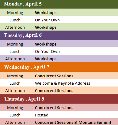
Click Here to see the detailed schedule, speakers, and session descriptions! Online Registration for Workshops is now closed. Contact kenny.ketner@gmail.com with questions. Workshops are scheduled for Monday and Tuesday, April 5- April 6 View the Full List of Workshops
The 2021 Big Sky GeoCon Committee and the Montana Association of Geographic Professionals (MAGIP) invite you to participate in the presentation of papers, electronic demonstrations and/or panel discussions during the 2021 Virtual Big Sky GeoCon, April 5-8. This year's Big Sky GeoCon will be an interactive virtual gathering attracting a wide variety of GIS users from federal, state, local, tribal and educational institutions as well as private organizations. With information geared to both new and seasoned users of geospatial technology, the conference is a great opportunity to share, connect, collaborate and be inspired. We encourage you to share your expertise, projects, stories or explorations in any GIS-related field via pre-recorded or live presentation. The MAGIP Community has demonstrated many creative and insightful ways to use maps, web applications, and other graphic forms to get their message out to their audience. If you have created maps that you are proud of and would like to display to a large group of GIS professionals, the Map Gallery would be a perfect opportunity to show them to the MAGIP community. We encourage you to enter your maps or web mapping applications to the Map Gallery, for display/viewing during this year’s virtual conference! All entries will be evaluated for possible cash awards totaling $700 by judges during the conference. Student Scholarships - Now Closed MAGIP is pleased to offer a limited number of scholarships to students currently enrolled in a higher learning institution. Students will be awarded free registration in exchange for working a set number of hours. Don't miss your chance to participate in the 2021 Big Sky GeoCon with opportunity for enhance exposure and to reach a larger audience with the virtual format.
|
Gold SponsorsSilver SponsorsBronze SponsorsSecure your spot as a Big Sky GeoCon Sponsor/Exhibitor! View the detailed |


